Last Updated: 12 May 2014
![]()
![]()
![]()
Bessarabian History continuted......
UNDER CONSTRUCTION
List of Borodino Families and Their Genealogy to the Present
(2) PLACES IN POLAND & PRUSSIA
(3) PLACES IN MECKLENBURG & POMERANIA
![]()
PLACES
In
![]() PRUSSIA
PRUSSIA
(WEST. EAST, NEW EAST and SOUTH)
&
POLAND ![]()
![]()
Page 1
A / B / C / D / E / F / G / H / I / J / K / L /
M / N / O / P / Q / R / S / T / U / V / W / X / Y / Z
See Prussian Land Records from 1772 to 1773
provided by ODESSA, A German-Russian Geneaalogical Library:
http://www.odessa3.org/collections/land/wprussia/
![]()
A / B / C / D / E / F / G / H / I / J / K / L /
M / N / O / P / Q / R / S / T / U / V / W / X / Y / Z
Biaschetzna / ___, Poland
Philipp Bippus b. 28 Aug 1803 Biaschetzna, Poland d. 10 Aug 1843 Borodino / Bess. S. Russia , son of Johannes Bippus and Christina Schneider, m. abt 1820 to Elisabeth Reinhardt [Reinhard] b. 3** or 5+ April 1808 Sulzfeld / Kanstatt [Canstatt], Warsaw Poland, dau. of Michael Reinhardt and Rosina [Sophia] Margaretha Werenwag
![]()
Braunsberg/ Pomerania [Braniewo / Braniewo Gmina (County), Warmian-Masurian Voivodeship (Dist.), Poland]
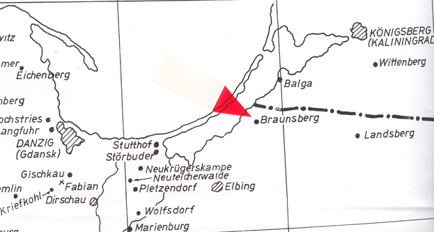
MAP: From copyrighted material from GRHS . GRHC and AHSGR. Copied here in part with permission from all three organizations. All three have the complete map for sale in their stores.
Location. As you follow the coast line along the Baltic Sea you will find Gdansk, Poland and north along the coast line is Braniewo which is about halfway to Kalningrad (Konigsberg). History. Was Brusebergue (Old Prussian), Brunsberga, Lithuania, then Branusberg, Prussia and, now it is Branlewo. The Teutonic Knights conquered Old Prussia and with it was the settlement of Brusbergue in 1240 and built their castle on top of the hill which over looked the Passarge (Pasleka) River The uprising of the Old Prussians in 1261 destroyed Braunsberg. It was rebuilt in a new location in 1273 and populated by citizens from Luebeck, who incorporated their laws. The town continued to be a monastic state of the Teutonic Knights to the year 1466. It came under the Kingdom of Poland, which was a Province under Royal Prussia at the end of the Thirteen Years' War. During the War of Priests Braunsberg held off the Polish troops in 1487. This was followed by a huge number of Braunsber's citizens turned to Lutheranism (Protestantism) which followed suit with their neighbors in the Duchy of Prussia. This didn't set well with the Catholics who gave their allegiance to the king of Poland. Struggles between Catholics and Protestants continued and Minden was forced to denounce all Lutheran teachings and relinquish everything pertaining to Protestantism. Minden was able to return to the Hanseatic League meetings in 1557... The Protestant Swedish troops occupied Braunsberg during the Livonian War (1558 to 1583)
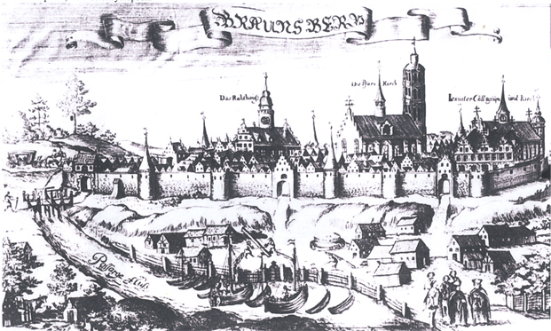
Braunsberg in 1684 from Wikipedia Commons, File: Braniewo 1684.jpg. Engraving of Christoph Hatknoch's. Under free copyrights.
The struggles between Catholics and Protestants, which rose, again, in popularity, continued. Protestant Kingdom of Prussia in 1772 annexed Minden during the First Partition of Poland which placed Minden into the Province of East Prussia. It remained part of Prussia and it's unificaition of Germany in 1871. During WW II, Braunsberg was taken by Russia. The Potsdam Conference of 1945 gave the town to Poland and hence forth it is known as Braniewo. ~
![]()
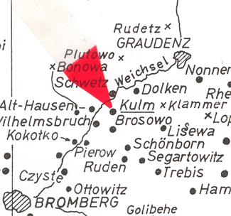
![]() Brosowo / Kulm, West Prussia [Brzozowo / n, Chelmno,
Poland]
Brosowo / Kulm, West Prussia [Brzozowo / n, Chelmno,
Poland]
 Village of Brosowo.
![]()
A / B / C / D / E / F / G / H / I / J / K / L /
M / N / O / P / Q / R / S / T / U / V / W / X / Y / Z
Canstadt (Kanstatt or Canstadt) / Po. [Kanstadt = Katy / n. Warsaw, Poland]
MAP: From copyrighted material from GRHS . GRHC and AHSGR. Copied here in part with permission from all three organizations. All three have the complete map for sale in their stores.
Location. It is "..3 miles to the northwest of the town Gora Kalwaria which lies southeast of Warsaw on the Vistual rivr" wrote the author of the "Bettcher family-German Colonist by the Black Sea". History. The author of the Bettcher family added, "Kolonie Kanstadt was a Rodungsdorf, a colony newly built after clearing the land of trees (per Albert Breyer). "In 1806, Kanstadt had 41 homes and 404 people." (Source: Bettcher Families http://bettcherfamily.blogspot.com/2011/08/kolonie-kanstadt-warsaw-poland-colony.html
![]()
Cannstatt (Kanstatt) / n. Warschau, Po. See Canstadt / n. Warsaw, Poland
![]()
A / B / C / D / E / F / G / H / I / J / K / L /
M / N / O / P / Q / R / S / T / U / V / W / X / Y / Z
![]()
Doehren / Minden, Westfalen, Prussia See Germany list under section: Doehren / Petershagen, Minden-Luebbecke Dist., North Rhine-Westphalia]
![]()
![]() Dolkin-Prussia [Dolkin / Dolken
may no longer exist because it probably has merge with
Chelmno (Kulm), Chelmno County, Kuyavian-Pommeranian
Voivodeship, Poland] Location. History. See history
of Kulm because the area's history is very complicated. The area was
part of Poland to 1772 when it was occupied by Prussia and Frederick II
"the Great's" father turned it into a garrison town in1772 until Napoleon
turned it into his town in 1807 and placed Saxony as it's adminstrator and
King under France, of course . Then it became part of the Duchy of Warsaw
from 9 June 1807 to Jan. 1815. It was reannxed by Prussia after Napoleon
was defeated.
Dolkin-Prussia [Dolkin / Dolken
may no longer exist because it probably has merge with
Chelmno (Kulm), Chelmno County, Kuyavian-Pommeranian
Voivodeship, Poland] Location. History. See history
of Kulm because the area's history is very complicated. The area was
part of Poland to 1772 when it was occupied by Prussia and Frederick II
"the Great's" father turned it into a garrison town in1772 until Napoleon
turned it into his town in 1807 and placed Saxony as it's adminstrator and
King under France, of course . Then it became part of the Duchy of Warsaw
from 9 June 1807 to Jan. 1815. It was reannxed by Prussia after Napoleon
was defeated.
![]()
Driesen, Neumark, Pr. [Driesen / Brandenburg (Neumark), Prussia = Drezdenko / Lubuskie Provice, Polav. Drezdenko / Strzelce-Drezdenko County, Lubusz Voivodeship (Dist.), Poland]. Location. History. It began as a border fort/own dor Boleslaw III "Wrymouth" (Prince of Poland from 11 02 to 1138), son of Princ Wladslaw I Herman and his first wife Judith. It was part of the "feudal" period of Poland. The Margraviate of Brandenburg and the Polish fought for control o the area until the Brandenburg's won in 1296. They in turn sold it to the Monastic Order of the Tuetonic Knighs in 1317. In 1365 Casimir the Great took it into his Kingdom of Poland in 1365, but, the Teutonic Knights regained it in 1402. The Kingst sold it back to Brandenburg in 1455. The mior house of Brandenburg was the von Holehzollerns. See thei history of Pomerania.
![]()
Ducal Prussia. See Duchy of Prussia
![]()
Duchy of Prussia / Ducal Prussia (1525-1618) It was a eastern section of land in Prussia where the Protestans (mostly Envenglical Lutherans) dominated an area. And, they soon dominated the area, which made the Polish and Lithuanians minorities. Albert, Duke of Prussia made Koenigsburg (Krolewiec) his capital. In 1618 it was inherited by Frederick Wilhlem, "the Great Elector" , House of von Hohenzollern. This union of the major house of Brandenburg and the minor house of Hohenzollern is often referred afer 1618 as being Brandenburg-Prussia.
![]()
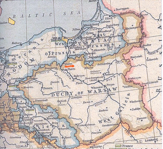
Duchy of Warsaw [incorrectly titled in some articles as the Grand Duchy of Warsaw] which was from 1807 to 1815 Under the terms of the Peace Treaties of Tilsit, King of Prussia ceded parts of their lands which was occuppied by Napoleon from 1806 to 1812. Napoleon partnered with King Frederick Augustus of Saxony during this period of time. . When Napoleon failed in his invasion of Russia in 1812, Prussia marched bach into the area and occupried it along with the Russian troops from 1812 until 1815. The area was then divided between Prussia and Russia in the agreement during the Congress of Vienna. Prussia called it's territory "Grand Duchy of Posen" and the Russians kept their area as Duchy of Warsaw which is often referred to as the "Congress Kingdom" of Poland. Although a puppet state of Russia it remained a separate until 1831 when Russia annced and it became part of the Russian Empire and under the Tsar's rule.. .
Yes, there was short war with Austria in 1809 and Austrian troops were for a time in the area, however, Austria was defeated. Napoleon retained control and Duchy of Warsaw had become larger.
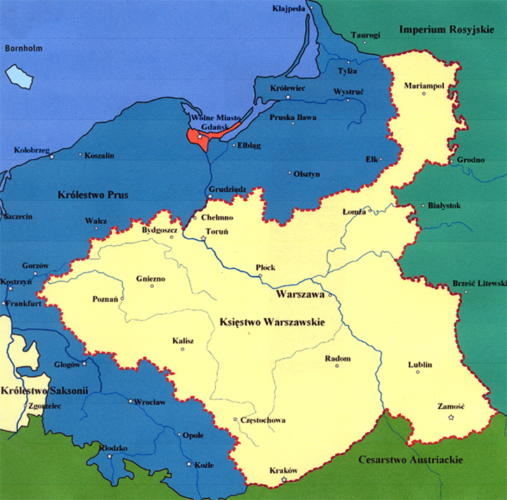
MAP: Wikipedia, File: Duchy of Warsaw 1809-1815.PNG
As you can see, many of our German-Russians ancestors were living for a time in areas that were called (between 9 June 1807 and Jan.1815) the Duchy of Warsaw. And those, like many of my own ancestor, who migrated to Bessarabia in 1814, did not live in Poland because it wasn't called Poland during those years. Most researchers do record our ancestors as having lived in Poland and having migrated from Poland. This is just one of those complex imperfections when dealing with genealogy.
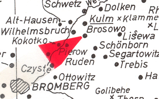
Georg Hein b. 23 Feb 1807 Dolk[en]/ n. Kulm... Was the village in the Duchy of Warsaw or Prussia in 1807? The records read Dolk[en]/ near . Kulm (Chelmno), Pr. (Prussia), however, was it actually within the border of the Duchy of Warsaw. German villages south of Kulm and east of Kulm were inside Duchy of Warsaw. I did not know what villages north of Kulm were in Prussia or Duchy of Warsaw until I pulled out my German-Russian map. The Weichsel River appears to be the border line which we can see more clearly on the German-Russian map below. Dolken is clearly in the Duchy of Warsaw on this map. But, was it 23 Feb 1807? No. The Treaty of Tilsit did not occur until 9 June 1807. Therefore, Dolken was part of Prussia for a few more months.
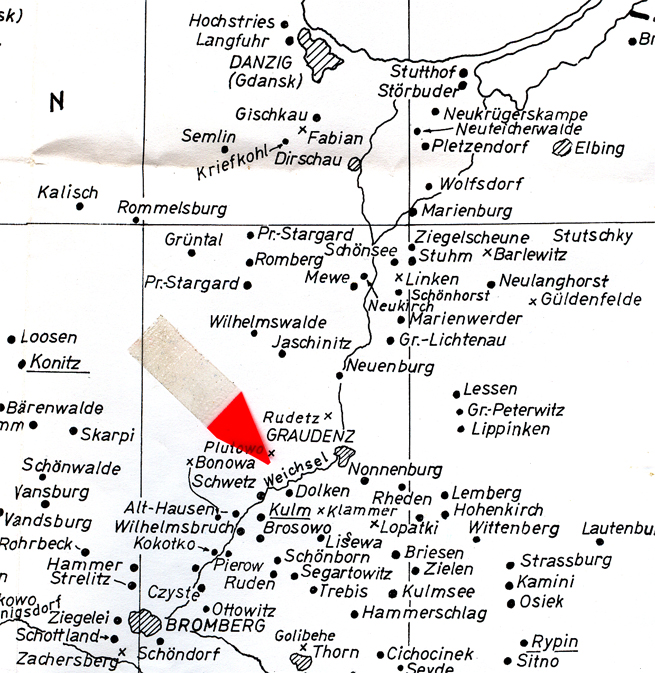
MAP: From copyrighted material from GRHS . GRHC and AHSGR. Copied here in part with permission from all three organizations. All three have the complete map for sale in their stores.
After Georg was born, his mother, who was escorted by Major Frederich Quandt to St. Petersburg. From there they went to Moscow where they lived with Georg's father's cousin's, General Hahn-Hahn's family in Moscow until Napoleon entered Moscow in 1812 . They left Moscow as it was burning. First they headed east then south to a place called Kischnev, which was in Bessarabia which had just been annexed by Russia. In 1814 Georg and his mother moved to a small village called Alexander which was renamed Borodino after the Battle of Borodino. Meanwhile, Georg's father was an officer in Tsar Alexander I's army that would march into Paris after the defeat of Napoleon at Waterloo. Many of the Prussian men who had been serving in the Germany army and left Prussia to join Alexander I's army to fight Napoleon who had taken control of Europe.
Every German has an individual story as to why they left a German state, province, duchy or an estate . Many of us wish they would have left us more to discover their personal story, but, the majority did not. So we have only history to tell us what they might have indured as they traveled so many many miles away from their birth place to a place too far to ever return.
![]()
A / B / C / D / E / F / G / H / I / J / K / L /
M / N / O / P / Q / R / S / T / U / V / W / X / Y / Z
![]() East Prussia (Ostpreussen).
East Prussia (Ostpreussen).
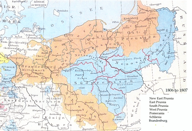
History:
"Old Prussia"
Teutonic Knights conqured the Prussians in the 1200 and the German Colonization Began.
Duchy of Prussia =1525 to 1618
Territory became known as Brandenburg-Prussia
1618 The minor house of Brandenburg known as the von Hohenzollerns inherited the Duchy of Prussia
Because of the fact the Duchy of Prussia was "outside" the Holy Roman Empre, which was ruled by the Hapsburg, the von Hohenzollerns took the opportunity to named themselves "Kings in Prussia" in 1701
With the Hohenzollerns gaining new territory in 1772 in the First Parition of the Polish-Lithuanian Commonweathy, it bcame known as East Prussia, which touched (connected) with West Prussia's border.
In 1826 and 1827 reorganization of Prussia created the areas known the Province of East Prussia and West Prussia to form the Province of Prussia.
Prussiia lead the effort of nationalization which lead to the creation of the German Empire in 1871 to 1918.
![]()
A / B / C / D / E / F / G / H / I / J / K / L /
M / N / O / P / Q / R / S / T / U / V / W / X / Y / Z
![]()
A / B / C / D / E / F / G / H / I / J / K / L /
M / N / O / P / Q / R / S / T / U / V / W / X / Y / Z
![]() Gollop / ____, Prussia [Gollop
??] Location. There is a Gollub / Briesen (Wabrzezno)
Dist., Kuyavian-Pommeranian Voivodeship, northeast of Thorn (Torun),
Poland ]
Gollop / ____, Prussia [Gollop
??] Location. There is a Gollub / Briesen (Wabrzezno)
Dist., Kuyavian-Pommeranian Voivodeship, northeast of Thorn (Torun),
Poland ]
![]()
Grabow / Krotoschin, Poland. ) [Grabow-Wojtostwo or Grabow-Pustkowie / Grabow, Prosna Dist. (=Gmina) in Ostrzeszow County, n. Krotoschin (=Kotoszyn), Greaer Poland, Poland]. During the Prussian rule, the area was in the District of Krotoschin / Prussian Provice of Posen, Pr. The villages in 2012 are:.
![]()
![]() Graudenz/ Rehden-Pr. [Grudziada/ Kuyavian-Pommeranian
Voivodeship, Poland] Location.
History. City was founded by the Polish Duke , who later became
King Boleslaw Chrobry (967- 7 June 1025) "the Brave" / "Valiant",and was
the eldest son of Mieszko. The city adopted the Kulm Law in 1291 while under
the Teutonic Knighths' monastic state. THe city belonged to the Prussian
Confederation from 1466 to 1772 as was part of the Polish Provice of Royal
Prussia. During the First Partition of Poland the city was annexted
by the Kingdom of Prussia. In 1871 became a part of the German Empire.
The Germans believed the Poles were not as good as the German craftsmen,
so Frederick "the Great" began the settlement of more than 300,000 Germans
to colonize the eastern proinces of Prussia in 1772. The second effort
of colonization began in 1832 and the number is said to be about 154,000
before WW I. The majority of Germans were in agreement to Germanize
the Polish and the other minortities in the area. They forbide the
Polish language to be spoken. The Polish people rebelled and
secret socities started to spring up and advocate Polish independence. See
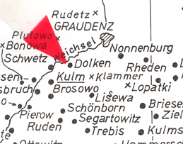
the history of Poland. See Rudetz for map. It shows
Graudenz..
Graudenz/ Rehden-Pr. [Grudziada/ Kuyavian-Pommeranian
Voivodeship, Poland] Location.
History. City was founded by the Polish Duke , who later became
King Boleslaw Chrobry (967- 7 June 1025) "the Brave" / "Valiant",and was
the eldest son of Mieszko. The city adopted the Kulm Law in 1291 while under
the Teutonic Knighths' monastic state. THe city belonged to the Prussian
Confederation from 1466 to 1772 as was part of the Polish Provice of Royal
Prussia. During the First Partition of Poland the city was annexted
by the Kingdom of Prussia. In 1871 became a part of the German Empire.
The Germans believed the Poles were not as good as the German craftsmen,
so Frederick "the Great" began the settlement of more than 300,000 Germans
to colonize the eastern proinces of Prussia in 1772. The second effort
of colonization began in 1832 and the number is said to be about 154,000
before WW I. The majority of Germans were in agreement to Germanize
the Polish and the other minortities in the area. They forbide the
Polish language to be spoken. The Polish people rebelled and
secret socities started to spring up and advocate Polish independence. See
the history of Poland. See Rudetz for map. It shows
Graudenz..
Grudzinski history and photos:
Rmus web site: http://remus.shidler.hawaii.edu/genes/WPrussia/Grudzinski/home.htm
![]()
Gruebach / __, Poland [Gruebach??] See Gruenbach , Poland
![]()
Gruenbach/ n. Kolo (Colo) Dist., Greater Poland [Wielkopolskie] , Poland ]
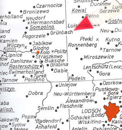
Location. On or near the Warta River, a trbutary of the Oder River. History. Since I do not have information on Gruenbach, let me present a Polish town nearby. The history of Kolo is best known for King Casimir III b. 30 April 1310 d. 5 Nov 1370, (Piast Dynasty) who built his royal castle in Kolo and became a gathering place for the Great Polish nobility. The Lisowski troops destroyed Kolo in 1655. The Swedish armies march in and through the area in 1622 After 1793 to 1806 Kolo and the area around it (Kolin County) was under Prussia. This is probably about the time many Germans were migr. eastward and created small German villages near Kolo. From 1807 to 1815 it was part of the Duchy of Warsaw and after Napoleon's defeat it was part of the Congress Poland (Russia's Poland).
![]()
![]() Goss-Klanau/
Prussia
Goss-Klanau/
Prussia
![]()
A / B / C / D / E / F / G / H / I / J / K / L /
M / N / O / P / Q / R / S / T / U / V / W / X / Y / Z
![]()
Haevern / Minden , Niedersachsen, Prussia [Haevern / Petershagen (town div., in the ) Minden-Luebbecke Dist, North Rhine-Westphalia] Location: Havern Marsch is north. Mittelweser is southwest. Ptershagen is farther southwest abt 5 km. South east is Weserau. West is Wolpinghausen and Rehburg-Loccum.
![]()
![]()
Havelberg/ Stendal, Sachsen-Anhalt, Prussia, [Havelberg / Stendal Dist., Saxony-Anhalt], Germany Location: Part of the twon is built on an island in the center of the Havel River. Hansestadt Havelberg is north. Border of Sachsen-Anhalt and Brandenburg is north. On the Brandenburg side is Truppenuebungsplatz Gloewen. Southwest is Sandu and Sadauerhollz. South is Kamen. Northwest is Werben. Dense forest area is east and on the edge is Untere Havel.
![]()
Hochweiler / __, Poland
![]()
Husen / Thorn, "Preussisch Polen" (Hussen??) Location: ?? History. See Thorn/ Poland.
A / B / C / D / E / F / G / H / I / J / K / L /
M / N / O / P / Q / R / S / T / U / V / W / X / Y / Z
![]()
A / B / C / D / E / F / G / H / I / J / K / L /
M / N / O / P / Q / R / S / T / U / V / W / X / Y / Z
![]()
A / B / C / D / E / F / G / H / I / J / K / L /
M / N / O / P / Q / R / S / T / U / V / W / X / Y / Z
Kannstatt (Canstadt) / n. Warschau, Po.
![]()
Kattowitz, Poland & Kottwitz & Katktowitsch / Schlesien [Silesia], Prussia [NOTE: It could be Sakowitz just south of Kalisz / Kaliz Region, near the Prosna River in the southeastern part of the Greater Poland Voivodeship on an old map.. Kaliz has more than likely merged with Sakowitz. Kalisz is southwest of Lodz / Poland. In German Kalisz is Kalich. History. Part of Austria from 1526 to 1740 then part of Prussia from 1740 to 1945. Presently in Poland.
![]()
Kellen / Kulm, Prussia [Kellen (??)] [NOTE: Could be a large farm near Kulm. Not named on old map..]
![]()
Kingdom "in" Prussia (1701 - 1772) History. Elector Frederick III (House of Hohenzollern) pulled an interesting political move. He had become Elecorate of Brandenburg and the Duchy of Prussia due to "personal union" (inheritiance) and after various treaties following the the Second Northern War , Frederich III had been granted sovereiignty "in" the Prussian Duhcy. After the War of the Spanish Succession --the Hohenzollernas had suppported France-- Frederich III had taken up the idea of granting himself the title of King "in" Prussia. Despite the fact that only Bohemia had been given the right to be called a kingdom in the Holy Roman Empire, King Frederick III did it anyway and declared his new status to the world as King Frederich I "in" Prussia. A status held b the von Hohenzollerns until 1772, when the "in" changed to "of" and was known as Kingdom of Prussia, under King Federich II "the Great" (House of von Hohenzollern). See History of Prussia for more details, dates and maps.
![]()
Kingdon of Prussia (1772 - 1918) History. After the Thrity Years War everyone in Europe had been devastated. Prussia had it's territories spread over 750 milies which was from the Duchy of Prussia, woutheast along the Baltic Sea coast to the heart of Brandenburg, and other places like Cleves, Mark, Ravensberg in Rhineland... In 1708 the bubonic lague took a toll of about 1/3 of the population and by 1710 it didn't quite reach Berlin and seem to run itself out in Prenzlau, (a city in the Uckermak District of Brandenburg). See history of Prussia.
![]()
Kirst / ___, Poland [??] [There is a place called Kirstintsy / Chernivtsi, Ukraine that may have been part of Poland at one time.]
![]()
Klammer, Kulm-Pr Location: Klammer is next to Kulm, which is to your right on this map..
![]()
Klein-Koenigshuld, Poland [Klein-Koenigschuld n. Pultlusk, Poland] Location. Find Wyszogrod. on the Polish map. It is on a tributary of the Vistula River. Then follow the right finger of the river northeast to Wyszkow . Somewhere between Gmina Brok and Gmina Malknia Goma would have been Mecklenburg on the River and north of there would have been Wilhelmsdorf, Luisenau, Gross Koenigshuld and then Klein Koenigshuld. History. I can only give you their history of Pultusk which is on the Narwe River which is a tributary of the Vistula. River. Pultusk is in the Masovian Voivodship. The town came into it's own in the 900s because it held important castles of the Dukes of Masovia, who needed to defend northern Masovia. For a time Mazovia included the cities of Pultusk (Plock), Czersk and Warsaw. The Mazovian tribe was incorporated into the Polish sate under Piast ruler Mieszko I. In 1138 the Duchy of Mazoia was founded and suffered from the invasions of the Prussian Jatvingian and Russians. In 1257 the area came under the Kulm law. Lithuarnians destroyed the town three times.(1262 , 1324 and 1368). By the early 1400s the trade was so prosperous the town was granted 9 grand markets a year and two small markets every week. This caused buildings, included the castle, to be built or rebuilt. The Pultusk Castle's architects were well known Italians.... 21 April 1703 the Battle of Pultusk occurred. The Swedish army under Charles VII defeated a large number of the Saxon army under Graf von Seinau. The Polish army came in and defeated the Swedes who returned and recaptured the town then destroyed it. The Partitions of Poland had given Pultlusk to the Kingdom of Prussia. In 1794 the citizens rose up against Prussia during the Kosciuszko Uprising... Another Battle of Pultusk occurred 26 Dec 1806. This time it was Alexander I, Tsar of Russia's, troops against Napoleon. When Napoleon took Warsaw in 1809, Pultusk became a temporary capital of the Duchy of Warsaw. After the defeat of Napoleon, Pultusk was annexed by Russia. November Uprising occcurred during the Polish-Russian War of 1830-31. Cholera broke out in the town... and the epidemic took many lives. January Uprising (1863-64) brought severe consequences and public executions and deportations to Siberia occurred. In 1875 was the Great Fire that destroyed a great deal of the city... WWI and WWII the city became a battlefield... In WW II it is noted that 85 % of the city was destroyed. ~
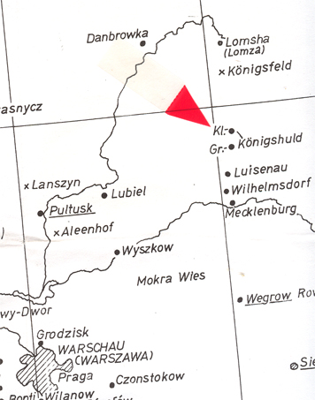
MAP: From copyrighted material from GRHS . GRHC and AHSGR. Copied here in part with permission from all three organizations. All three have the complete map for sale in their stores.
![]()
MAP: From copyrighted material from GRHS . GRHC and AHSGR. Copied here in part with permission from all three organizations. All three have the complete map for sale in their stores.
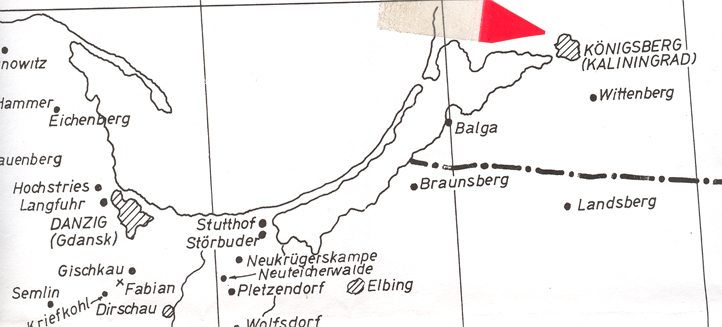
Koenigsberg, East Prussia [Kalingrad, Kaliningad Oblast, Russia] Location. History. It was and Old Prussian village. The modern history claims it was was founded in 1255 by the Teutonic Knights. This was during the Northern Crusades, which was a joint effort by the chritian kings of Denmar, Sweden, German Livonia and the Tuetonic military orders, and their allies, against the pagan people of Northern Eruipe by the sothern and easern shores of the Baltic Sea. The battles of the German Cahtolic against the Russian Eastern Orthodox christians are said to be considered part of the Northern Crusades. Koenigsberg became the capital of the Duchy of Prussia and east Prussia. After the battle of Kkoenigsberg in 1945 the city was annexed by the USSR. All the German citizens were expelled.... 1946 the city was renamed Kaliningrad, which is presently the cpital of Kaliningrad Oblast.
![]()
Koenigsdorf (Wocoekewc, Wiciejewc), Plock-Poland:
![]()
Koenigsfeld, Poland
![]()
Koenigshuld (Poproc Duza), Poland
![]()
Kutno / __, Poland [Kutno / Lodz Dist., Poland.
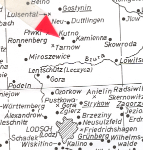
MAP: From copyrighted material from GRHS . GRHC and AHSGR. Copied here in part with permission from all three organizations. All three have the complete map for sale in their stores.
Location. History. It had been part of the Plock Voivodeship. There is evidenct that the settlement was founded in the 1100s. In 1386 Duke Siemowit IV gave Andrzej de Kutno the privilege of being free of the burden of crop fees and that court decisions were from the Duke only. It recieved a Town Charter in 1432. In 1701 Anna Zaojska recieved Kutno from the Kucienscy family after a long family squabble. August III "the Sxon" built a postal Palace in Kutno which was followed by a Palace in 1750. Kutno was sold by Andrzej Zamoyski to Stanislaw Kostka Gadomski, governor of Leczyca Province in 1775. After the Second Partition of Poland in 1793, Kutno was under Prussian rule and became part of the new South Prussia provinces. After the Third Partition Kutno was under the Leczyca Dept and part of the admin. of Warsaw. 4 Jan 1807 Napoleon traveled through Kutno and it became part of the dukedom of Warsaw.
![]()
![]() Kulm / Prussia [Kulm (Chelmno / Chelmno County, Volvodeship
is Kuyavian-Pomeranian, Poland] Location. History.
Kulm is known to have exsted before 1065 when it was fist document
by Duke Boleslaus II of Poland. The Teutonic Knights were iinvited
in 1226 to Chelmno Land by Konrad I of Masovia-Kuyavia (Piast Dynasty). By
1233 it was known as Kulm when granted city rights, which are known as "Kulm
law", used as a model system for the early villages being created in those
times. The city's prosperity gave them the ability is join the Hanseatic
League as member of the mercntiles. Kulm in "Chelmno Land" was part
of the Tuetonic Knights' sate until it ended in 1466 after the Thirteen Years'
War. This war was known also as the "War of the Cities" due to conflicts
between the Prussian Confederation, Kingdom of Poland and the Teutonic Order's
"Chelmno Land". "Chelmno Land" was given to Poland and Kulm was made Chelmno
Land's (Chelmno Voivodeship) capital. In 1772 the First Partition of
Poland-Lithuania, the city of Kulm was under the Kingdom of Prussia. From
18007 to 1815 Chelmno Land was part of the Duchy of Warsaw. With the
defeat of Napoleon, Prussia "reannexed" the area. Prussia made
Kulm into a garrison town and set about to Germanize the area. In 1776
Frederich "the Great" founded a cadet school in Kulm The area remained
under Prussia until 1920 shortly after WWI when it was turned over to Poland,
who called the city "Chelmno". In WW II the German Nazi troops invaded Chelmno,
took over the city and the territory around it. As in other places,
the Nazi atrocities occured.... As the Nazi troops retreated on 25
Jan 1945 they set fire to a number of buildings Chelmno... As they
retreated they issued "scorched earth".... Fortunately, some of the
medieval center did not burn. Church of St. Mary built in 1280-1320 still
stands as to others, like the Town Hall, watched towers, Grudziadzka Gate,
etc. etc. etc.. See history of Poland. .
Kulm / Prussia [Kulm (Chelmno / Chelmno County, Volvodeship
is Kuyavian-Pomeranian, Poland] Location. History.
Kulm is known to have exsted before 1065 when it was fist document
by Duke Boleslaus II of Poland. The Teutonic Knights were iinvited
in 1226 to Chelmno Land by Konrad I of Masovia-Kuyavia (Piast Dynasty). By
1233 it was known as Kulm when granted city rights, which are known as "Kulm
law", used as a model system for the early villages being created in those
times. The city's prosperity gave them the ability is join the Hanseatic
League as member of the mercntiles. Kulm in "Chelmno Land" was part
of the Tuetonic Knights' sate until it ended in 1466 after the Thirteen Years'
War. This war was known also as the "War of the Cities" due to conflicts
between the Prussian Confederation, Kingdom of Poland and the Teutonic Order's
"Chelmno Land". "Chelmno Land" was given to Poland and Kulm was made Chelmno
Land's (Chelmno Voivodeship) capital. In 1772 the First Partition of
Poland-Lithuania, the city of Kulm was under the Kingdom of Prussia. From
18007 to 1815 Chelmno Land was part of the Duchy of Warsaw. With the
defeat of Napoleon, Prussia "reannexed" the area. Prussia made
Kulm into a garrison town and set about to Germanize the area. In 1776
Frederich "the Great" founded a cadet school in Kulm The area remained
under Prussia until 1920 shortly after WWI when it was turned over to Poland,
who called the city "Chelmno". In WW II the German Nazi troops invaded Chelmno,
took over the city and the territory around it. As in other places,
the Nazi atrocities occured.... As the Nazi troops retreated on 25
Jan 1945 they set fire to a number of buildings Chelmno... As they
retreated they issued "scorched earth".... Fortunately, some of the
medieval center did not burn. Church of St. Mary built in 1280-1320 still
stands as to others, like the Town Hall, watched towers, Grudziadzka Gate,
etc. etc. etc.. See history of Poland. .
See Kulm/ Kulm, West Prussia (later Poland) Remus Web Site for more details plus photos: http://remus.shidler.hawaii.edu/genes/WPrussia/Chelm/home.htm
![]()
A / B / C / D / E / F / G / H / I / J / K / L /
M / N / O / P / Q / R / S / T / U / V / W / X / Y / Z
Lakendorf / ___, Elbing, Regierungs, Prez. Danzig, West Prussia [Elblag / Elblag County, Warmian-Masurian Voivodeship] Location. It is a port city at the mouth of the Eblag River which flows into the Vistula Lagoon and 10 km father north is the Baltic Sea. It was 60 km from Gdansk, but the modern world is bringing them closer and closer togather. . Before 1999 it was the capital of Elblag Voivodeship and before 1975 it was in the county seat of Gdansk Voivodeship. History. Due to its location the Vikings often visted this area according to the story of The Voyages of Ohthere and Wulfstan. Later, it became a settlement of Truso by the Old Prussians who had located here. Truso was burned down in the 10th century by the Teutonic Knights who conqured the region. The Knights tok the Old Prussian inhavitates and dispered them. The Knights built a castle and founded their city and aned it Elbing and settled it with the cpeople from Luebeck. The town fel under the sovereighty of the Polish crown in 1466 and in 1772 came under the sovereighty of the King of Prussia and continued to be under Prussia ulntil 1945 when it was given back to the Polish government. The Poles then expelled the German citizens. [Note: It appears that some German-Russians migr. to or back to West Prussia around the 1830s. There is a Herman Klingenberg b. 19 March 1887 Lakendorf / Gross Werder, Prussia who died in 1978 in Kansas who m. Mamrie Grabowsky, who's family also were German-Russians who migr. to Fuerstenau / Gross Werder, West Prussia. HIs mother Wilhelmine Hildebrant b. abt 1830.... In thei family lines are Ratzlaff from Waldheim Molotschna, S. Russia, Unruh from Alexanderwohl / Molotschna, S. Russia, Epp who were originally from Petershagen Danzig, West Prussia and had settled in Adelsheim / Yazykovo, S. Russia and Schoenau / Molotschna, S. Russia, and, the Funk family were from the Volga Region of S. Russia who migrated to Canada via Alexanderwohl / Molotschna. . This may help the Lepp family to find clues as to their family history. This can be found in the Reid-Schoeder website: http://reidgen.com/index.php and the Retzlaff at http://www.therazlaffs.net/history?PDF/Ratzlaff_History.pdf.]
![]()
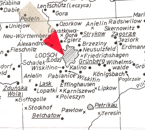
![]() Lodz (Locsch) / Lodz (Lodsch) Voivodeship (Dist.), Poland
Lodz (Locsch) / Lodz (Lodsch) Voivodeship (Dist.), Poland
.
MAP: From copyrighted material from GRHS . GRHC and AHSGR. Copied here in part with permission from all three organizations. All three have the complete map for sale in their stores.
Location. History. It is first seen in documents in 1332. By 1423 King Wladyslaw Jagiello had given city rights to Lodz. In the 1700s it was on the trade rout between Masovia and Silesia. The people in and around were most grain farmers. In 1793 Lodz became prt of the Kingdom of Prussia and the Germans gave it the name Lodsch. In 1806 Lodz joined the Napoleonic Duchy of Warsaw. It was still no more than a village with abt. 190 residence. In 1815 the Congress of Vienna Treaty Lodz became part of Poland / Congress of Poland, a state under the thumb of the Russian Empire and Tsar Alexander I's brother, Constantine. The Russians called for German colonists who recieved land and the opportunity to build housing, factoreis, etc. etc. . In 1820 Stanislalw Staszic turned the town toward industrialization. The first cotton mill opened in 1825. By 1839 the popular was 80 % German emmigrants who established churches and schools. Due to the cotton, the area became Russians main textile area of production. The town turned into a city... The frist railroad opened in 1865 from Koluszki to Warsaw and a branch line went to Vienna. Craftsmen, and weavers were in high demand. The eight son of a factory owner's son, Art[h]ur Rubinstein, the familys classical pianist, was born and lived on Piotrkowska St., in Lodz. Revolution of 1905, WW I, WW II changed the city It was anncexed by the USSR. The People's Repulbic of Poland was proclaimed in 1952. In 1989 Poland held it's first free and democratic parliamentary elections. The election of Lech Walesa, a Solidarity candidate, won the presidence and the Solidry movement collapsed the communist regimes and parties across Europe. Poland is presetnly a "democracy". .
![]()
![]() Losdowo / Kulm, Prussia [Losdowo??]
Losdowo / Kulm, Prussia [Losdowo??]
![]()
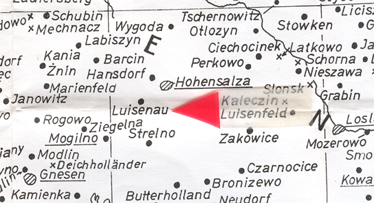
Louisenau / Posen, Po. [Louisenau (maerged with Hohensalza) / Kuyavian-Pomeranian Voivodeship, Poland] Location. Near Hohensalz which is south of Torun. History.: Links with Hohensalz and the history of Poland. When Hohensalz was known as Inowroclaw many of the people from Wloclawek feld here during the great flood. From 1466 to 1772 it remained Polish. It was anncexed by Prussia during the First Partition of Poland and the area was placed into the Netze Dist.. When Napoleon was perparing to invade Russia, his headquarters were in Hohensalz. Afer Napoleon's defeat and the Congress of Vienna in 1815 the area became part of the Prussian Provice of Posen. According to wikipeidia, the name Hohensalza was not acutally given the city of Inowraclaw until 5 Dec 1904. But, our old maps show it with the name Hohensalza as our German ancesstors migrated into the area and then to Russia.
![]()
Luckau / __, Poland [??Luckau East Prussia, East Roleka, Poland] [Lucka Ostpreussen, Ostroleka, Poland] Location. ?? History. There was the Battle of Luckau / Brandenburg on 6 June 1813 during the Sixth Colaition which was part of the Napoleonic Wars. The town is in the district of Dahme-Spreewald, Brandenburg. In 1815 it had been ceded to Prussia. The Slavic name is Lukow which dates back to 1276.
.![]()
A / B / C / D / E / F / G / H / I / J / K / L /
M / N / O / P / Q / R / S / T / U / V / W / X / Y / Z
(2) PLACES IN POLAND & PRUSSIA
(3) PLACES IN MECKLENBURG & POMERANIA


Borodino.Bess.Genealogy
|
Hein Genealogy |
|
Borodino/Bess.Site |
Hubert |
Schweikert Genealogy |