German Emigration to Borodino, Bessarabbia, Russia: 1812-1840s.
Last Updated: 25 Sept 2012
![]()
![]()
![]()
Bessarabian History continuted......
List of Borodino Families and Their Genealogy to the Present
----
(2) PLACES IN POLAND & PRUSSIA
(3) PLACES IN MECKLENBURG & POMERANIA
.
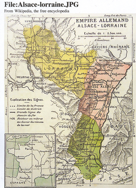
ALSACE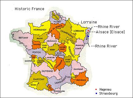 ELSASS
FRANCE
In French the area is known as Alsace. When it was in German hands it was called Elsass or Alsace, earlier in history it was part of the Elsass-Lothringen.. Presently most of Alsace is on the eastern border and in France next to the Rhine River and across the Rhine River is Germany. The area comprises of Bas-Rhin[e] and Hut-Rhin[e]. The chief cities are Strasbourg, Comar, and Mulhouse. The history is difficult to follow at times because it has been pulled back and forth from French hands to Germans hands. In 870 it was part of the East Franksih Kingdom. The Peace of Westphalia in 1648 carried it to French hands by annexations when Louis XIV was king. But not all of the area was annexed, at least not until the French Revolution. It was ceded to Germany and became part of the Lorraine in 1871. The French regained control in 1918. During the Great War [WWI], Germany occupied Alsace area. After the defeat of Germany, Alsace most of Alsace became part of France and has remained so since that time.
..
PLACES IN ALSACE
.
A /B / C / D / E / F / G / H / I / J / K / L / M / N / O / P / Q / R / S / T / U / V / W / X / Y/ Z /
.
.
Alsace History. There was a Celtic Alsace until the Roman invaded in 58 BC and established a center for vitculture. When the Roman Empire declined, the territory fell into the hands of the Alemanni people. Realizing the importance of Alsace area, Clovis and the Franks marched into the area in the 5th century...... The grandsons of Charlemagne inhierted part of their grandfather's domain. This created Middle Francia, Lothariingia (Lorraince) and two brothers shared the West Frankish area. In the treaty of Meersen in 870- the region known as Alsace went into the hands of he Holy Roman Empires and was merged with the Duchy of Swabia. Vikings raided Alsace from 889 to 962. Politics, wars, inhertitance squabbles and greed splintered Alsace the Alsace area even more. The 14th centuury was miserable for Alsace area. There were extra cold winters, harvests that failed and rotted, a terrible earthquake and then the Black Sea that eliminated huge numbers of people. The French became agress toward the Alsace area.... The Thirty Years' War interupted the French's desires but rose up again when the war was finsihed. In 1444 the French troops moved into Lorraine and Alsace... In 1469 the Treaty of St. Omer caused Archduke Sigismund of Austria to sell Upper Alsace to Charles the Bold, Duke of Burgundy but Frederick III, the Holy Roman Emperor bought back Upper Alsace in 1477. Despite the Catolic Habsburg's efforts, the Protestant Reformation created many of it's citizens left the Catholic Church and the areas became doted with the new circles who became known as Protestants. The largest group of Protestants were in the southwest of Alsace which was under the rule of Counts of Wuerttemberg. The Franco-Dutch war came the French sovereignty over the area, again. The French Revolution changed borders.... As the Germans fled, the French confiscated lands as they moved and occupied areas.... There were two large waves of Germans who migrated to Austria-Hungary and/or Russia. 1794 Germans who settled in Catherine II "the Great's" Russia area along the Volga became known as the Volga German-Russians. In 1804-5 and 1809 migrated to the Black Sea area (New Russia) under Alexander I. Conditions in the French controled Alsace were not a place where the Protestants wanted to remain. And, the lack of good crops caused hunger... In 1843 and 1844 ships were sailing to New York, USA filled with Alsatian.... 1870 to 1871 was the Franco-Prussian War. The Prussians came out the victors and boders changed, again. Elsass-Lothringen was created..
Alsace-Lorraine: Created by the German Empire after it annexed most of the Alsace and the Moselle region of Lorraine after the Pranco-Prussian War.
WWI borders changed. Treaty of Versailes cause Germans to lose Alsace to France (1919-1940)
1940 to 1944 the Nazi Germany invaded Alsace and took control. Having lost the war, the Germans lost Alsace and in 1945 became part of France and has remained under the French rule.
.
.
.
 Click and go to larger map, see list of Dept.
and towns......
Click and go to larger map, see list of Dept.
and towns......
The Karl Stumpp Book (The Emigration from Germany to Russia in the Years 1763 to 1862) lists the following "Kantons" from which German migr. to Russia. Place name is folllowed by number of families:
Note#1: A number of my husband's families, Hubert and Hummel, migrated from Alsace to Banat (n. Temesvar) and Arad Regions of Austria-Hungary . See List and maps....etc. etc. etc..
NOTE #2: A number of my own ancestors migr. from the Alace to Russia and they were:
.
.
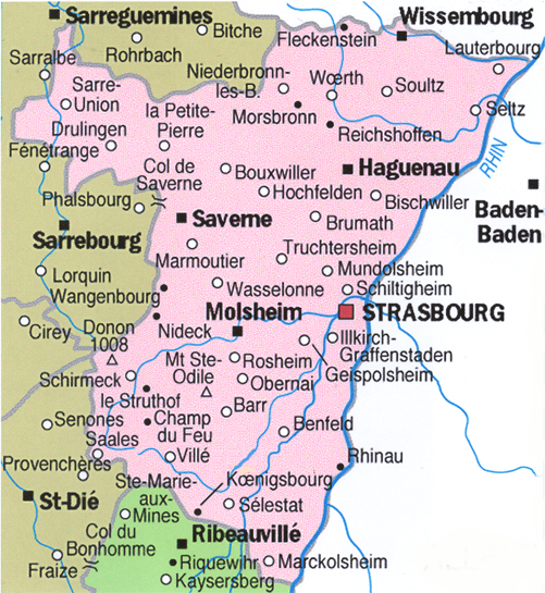
Bas-Rhin Dept., France Location. Map from Wikepedia - Communes of Bas-Rhin. History. Means lower Rhine [River]. The area presently called Bas-Rhin was created during the French occupation (1790s) of the left (west) side of the Rhine River to Napoleon's second defeat in `1815. The Congress of Vienna turned over this area to Rhineland-Palatinate. Following WW II, the area was occupied by France. Strassbourg is the capital. See Alsace for more detailed history.
There are 527 communes of the Bas-Rhin Departement in France. Here are just a few mentioned by our Borodino / Bess., Russia places of origin or places from which they left before trek to Russia:
.
![]()
.
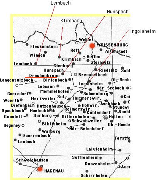
Burgoesch / Sulz, Alsace [_?__ / Soultz-sous-Forets which is n. and west of Woerth / Bas-Rhin Dept, Alsace , France and direcctly south of Wissenbourg (abt 10 miles)..
.
![]()
A /B / C / D / E / F / G / H / I / J / K / L / M / N / O / P / Q / R / S / T / U / V / W / X / W / Z /
.
.
A /B / C / D / E / F / G / H / I / J / K / L / M / N / O / P / Q / R / S / T / U / V / W / X / W / Z /
.
.
Dachenbronn / Weissemburg, Alsace [=Drachenbrennen/ [Drachenbrennen/ Dept of Base-Rhin, Alsace, France] This area next to the border of Rhineland-Palatinate has been pushed back and forth between Germany and France a many times. Before the French Revolution it was occupied by the French. in the 1790s French. After Napleon's deafeat in 1815 it was given to Bavaria....Presently it is part of France. Weissemburg (German)= Wissembourg (French)= "White Castle" (English)
.
![]()
.
Dangolsheim / Molsheim Canton, Bas-Rhin Dept., Alsace, France Location: Abt 22 km west of Strasbourg, north of Mutzig (Mussig), east of Flexbourg and south of Scharrachbergheim-Irmstett and Westhoffen.. See Dengolsheim in Alssace Section..
.
![]()
.
Dengolsheim / Sessenheim, Hagenau, Alsace [Dengolsheim = Dangolsheim / Bas-Rhin, Alsace, France west of Strasbourg. See Dangolsheim and Sessenheim.
.
![]()
.
A /B / C / D / E / F / G / H / I / J / K / L / M / N / O / P / Q / R / S / T / U / V / W / X / W / Z /
.
.
.
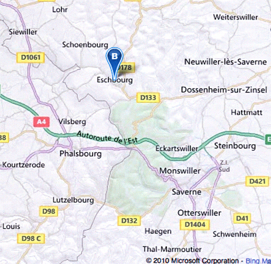
Eschburg, Alsace [Eschbourg, Township of La Petite-Pierre, Saverne Dist., Bas-Rhin Dept., Alsace, France] Location. East is Neuwiller-les-Saverne and Dossenheim-sur-Zinsel. Farther southeasst is Strasbourg. South is Eckartswiller and Phalsbourg. West and slightly north is Hirschland and Siewiller. Map: Part of a Modern map of 2010 from Microsoft Corporation. See Strassbourg Map. Ancesstry.com. History.
.
.
.
.
Hunsbach / Alsace. See Hunpach.
.
![]()
.
Hunspach / n. Weissenburg, Alsace = Hunspach / n. Wissembourg, Alsace, Bas-Rhine Dept., France Location. History.
.
.
.
.
.
.
Landau / Alsace (Elsass) Along the border of France there is a Petit-Landau / Haut-Rhin, Alsace.
.
![]()
.
Lembach / Elsass (Alsace) [Lembach, Wissembourg Canton, Depart. of Bas-Rhin, Alsace Region, France] See history of Alsace which was constantly pulled back and forth between Germany and France. Merged with Mattstal in 1972. See Chateau de Fleckenstein, known to have existed as early as 1165 and owned by the Fleckenstin family until 1720 when it passed to the Vizthum d'Egersberg family. From 1807 to 1812 it was in the Apffel family. It went back to the Fleckenstein (Pierrebourg) family in 1812. In 1919 it became the property of the France. The Froensbourg Castle may have been in the Fleckenstin family's side. Documented as early as 1`235. The Palaine Count restored the castle in 1358. Destroyed by the French in 1677. .
.
![]()
.
Lingenhausen / Alsace
.
.
![]()
.
Lotharingia, Duchy of
.
![]()
.
A /B / C / D / E / F / G / H / I / J / K / L / M / N / O / P / Q / R / S / T / U / V / W / X / W / Z /
.
.
Menchoffen, Alsace [Menchoffen, Commune of Bas-Rhin, Alsace, France (Frankreich) ] Location. Southwest of Wissenbourg, North and slightly west of Strasbourg. Nearby is Niederbronn-les-Bains to the north northwest. West is Gundershoffen and Mertwiller and southeast is Pfaffenhoffen and farther. southeast is Haguenau abt 18 km. South and slighty west is Saveme. Next door to the north is Ingwiller. History.
.
.
Neuwiller Bas-Rhine, France [Neuweiller / Reichshoffen, Bas-Rhine, Alsace, France] Location: In northeastern, France. South is_____ East is Langensoultzbach, west is Niederbronn-les-Bains. North is Windsteim. North northeast is Lembach abt 6 km
.
Neuweiler/ Haut-Rhin Dep., Alsace, France Location: aby 7 km from Basel, France.
Neuwiller is French, Neiwiller is German
.
.
![]()
.
A /B / C / D / E / F / G / H / I / J / K / L / M / N / O / P / Q / R / S / T / U / V / W / X / W / Z /
.
.
.
.
.
.
Schlettstadt / Alsace [Schlettstat / Bas-Rhin Dept., Alsace, France] Location. North northeast is ebersheim. East is Muttersholtz. Souldwest is Aaint-Hippolyte. Westa nd slightly south is Kintzheim. West and slight north is Chatenois. Northwest is Scherwiller. History. It is Selestat in French, Schestatt in Alsatian and or Schlettstadt in in German.
.
![]()
.
Sessenheim / Hagenau, Alsace [Sessenheim / Haguenau, Bas-Rhin Dept, Alsace, France] Location: North is Soufflenheim, south is Dalhunden, east is Huegelsheim and west is Schirrheim and farther east is Haguenau. This area was one part of German but presently it is part of the northeastern part of France. Hisory. According to one article I read, it is a "...little, rustic village "; the history is easy to miss" and known because of the German Johann Wolfang von Goethe, who fell in love with the local pastor's daughter". Goethe was from `770 to 1771 a student in Strasbourg and spent a lot of time in Sessenheim during that years. See Alsace Section
.
![]()
.
.
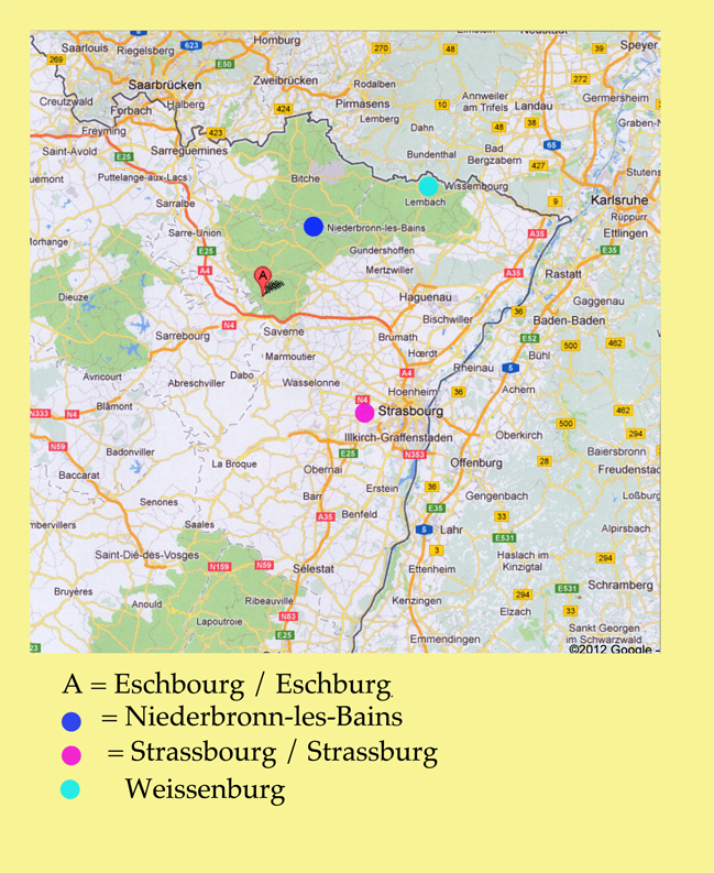
Strasburg, Alsace. See history which tells a great deal about the area of Alsace and the battles between the French and the Germans through the years. I believe a history teacher of mine stated that the area had been handed back and forth about 40 times at last count if a person counted every move. Google Map above is modern map, 2012, of the Strassbourg area.
.
![]()
.
Soufflenheim / Bas-Rhein Dept., Alsace, France Location. Soufflenheim / is next door to Sessenheim. Bischweiler is west and slightly south. History. It is known for it's pottery. It has been discovered tha molds date back to 400 B.C.. In 1147 Emperor Frederich I "Barbarossa" gave the potters of Soufflenheim the right to extract clay from the clay pit in Haguenau forest, which was part of the Emperors hunting grounds and this right continues up to the present. Accrdig to legend, a potter save the Emperor from a large boar. This could be "Sufflenheim" mention in Sufflenheim / Bischeiler, Alsace where the Buerger family is said to have originated. It is interesting --to me-- that Alsatian is still spoken here as well s most of Alsace. Alsatian is "Low Alemannic German" which is related to German spoiken by Swiss Germans, Swabian and Badisch (Baden area).
.
![]()
.
Sundhouse (Sundhaus = Sundhouse) / Bas-Rhine Dept., Alsace, Germany (presently in France) The French and German border is next to Sundhouse. North northeast is Freiburg / Baden-Wuerttemberg. The nerest German village on the other side of the border is Rust. North is Wittisheim. West is Selestat (Schlettstadt, which is shown on the GR maps. South is Marckolsheim and south and slightly west is Weiswell , Baden-Wurttemberg. Stuttgart / Stuttgart Dist., Baden-Wuerttemberg is about 40 km north and slightly east of Sundhouse. It is a "commune" in Alsace in north-eastern France. The area is called "Unterelsass" which means it is part of the Lower Rhine River. See Bas-Rhin for history in more detail. It was on 4 March 1790, which was during the French Revolution, that the Freach created the Bas-Rhin Dept. as they held the entire left (west) bank of the Rine River. When Napoleon was defeated in 1815 the Congress of Vienna assinged the areas north of the Lauter River to Bavaria and those territories are. mpw. om tje Rhineland-Palatinate, which is a German state. The area was reclaimed by the Germans in 1871 when they defeated the French in the Franco-Prussian War and held it until after WW II in 1918. The area of Sudhouse became part of the Bas-Rhine Dept. in France. [Sundhause is 201 km car ride from Moehringen, which is near Stuttgart, Germany. By car it would be a 2 hour and 25 minute drive.
.
![]()
.
Sufflenheim / Bischweiler, Alsace [Soufflenheim / n. Bischweiler, Bas-Rhein Dept., Alsace, France.] See Soufflenheim.
.
![]()
.
A /B / C / D / E / F / G / H / I / J / K / L / M / N / O / P / Q / R / S / T / U / V / W / X / W / Z /
.
.
.
.
.
.
.
Wingen/Weissenburg, Alsace [Wingen / n. Wissembourg, Bas-Rhin Dept., France] Location. Abt 9 km east is Wissenbourg. . South and slightly west is Lembach. North is Bruchweiler Barenbach which is in Gemany. The border is abt 2 km.. West is Dambach.
.
![]()
.
A /B / C / D / E / F / G / H / I / J / K / L / M / N / O / P / Q / R / S / T / U / V / W / X / W / Z /
.
.
.
.
![]()
.
A /B / C / D / E / F / G / H / I / J / K / L / M / N / O / P / Q / R / S / T / U / V / W / X / W / Z /
(2) PLACES IN POLAND & PRUSSIA
(3) PLACES IN MECKLENBURG & POMERANIA


Borodino.Bess.Genealogy
|
Hein Genealogy |
|
Borodino/Bess.Site |
Hubert |
Schweikert Genealogy |